Showing posts with label early warnings. Show all posts

Wednesday, July 26, 2017

A perfect storm is brewing - and we can prevent it

by Pradeep Kurukulasuriya 


As we move further into the 21st century, all indications are that we will not only see increases in average temperatures, but also more frequent and more intense severe weather, changing rainfall patterns, droughts, floods and sea-level rise around the globe.
Just this month, the city of Jilin in China was severely flooded and more than 110,000 people had to be relocated, with 18 reported dead. The death toll from flooding caused by heavy rain in southern Japan has risen to at least 15. Just last week, a flood at a popular swimming hole in Arizona killed 9.
This threatens each and every single one of us. You might have read all about it in David Wallace-Wells´ recent piece in New York Magazine.
But preventing new and reducing existing climate risks in order to save lives, businesses, communities and countries, is one focus set out in the Sendai Framework, the world’s blueprint for dealing with disasters.
To understand climate change induced-disaster risk, you need the effective deployment of climate and weather monitoring technologies. The data generated from this technology needs to then be used with socio-economic, biophysical and other data to generate estimates of risks. The collection, packaging and distribution of this understanding of risk forms the backbone of early warning systems.
Taken together these “climate services” can save lives from fast-acting storms, protect livelihoods and infrastructure, and work to break the cycle of disaster-risk-and-recovery that forces developing nations to take reactive – rather than proactive – approaches when bad weather hits. This cycle means that all too often vulnerable communities need to start again from zero, infrastructure needs to be rebuilt, and funds need to be re-allocated from key areas that show promise of breaking the poverty cycle such as education and health.  
Unfortunately, this is a step that’s easier said than done. The problem does not only come from a need for better suited technologies, it also comes from challenges to maintain the equipment and the systems that need to be in place to monitor and understand risks, or even overlapping systems that don’t fit well together. Moreover, even if we to get that right, another common constraint is, for a variety of reasons, resistance to behavioral change. That can lead to knock on effects including limited information sharing, a fear of new technologies, new partnerships and new approaches.
Paradigms are not easily shifted.
This is why UNDP is supporting an ongoing dialogue on “A New Vision for Climate Services” that explores a shift in technology and a shift in approaches to ensure end-to-end climate services and their connected early warning systems are easily deployed, affordable, effective and built to last.
The creation of effective early warning systems requires connecting any number of parties and sectors to analyze and distribute actionable early warnings that vulnerable communities can use to get out of harm’s way, protect their goods, and build more climate-resilient livelihoods. The information chain for an early alert extends across National Met Authorities, Disaster Risk Agencies, various ministries, executive branches, the media, and the civil society. With improved, reliable weather information, this information chain can connect diverse sectors to inform improved disaster risk governance, and ultimately, save lives.
Decision makers can use this information to transform the community´s vulnerability into resilience by offering capacities to coping with extreme events such as invest significantly in infrastructure projects for water, energy, transport and flood mitigation. This will strengthen local economies, lower migration caused by climate change, and help build climate-smart infrastructure designed to withstand the risks due to a changing climate. Private sector enterprises can also use the information to inform their own climate adaptation strategies, while on the community level, people can develop climate-resilient strategies to improve local enterprises and protect productive assets.
What´s more investment in effective end-to-end climate services is smart business. The projected cost-benefit ratio is regularly cited as five-to-ten-fold for every dollar spent on climate services. Think about this - over the past three decades, floods and droughts have already cost Zambia $13.8 billion, equivalent to a 0.4 percent loss in annual economic growth.
This said, investments in climate services should not just fall on the public sector alone. While early warnings are an essential public good and a key component of disaster risk reduction, private enterprises certainly benefit from improved weather and climate information, which can be used to avoid crop losses and improve productivity on the farm, support energy and extractive industries, allow for weather insurance, and build responsive business prepared for the new climate realities of the 21st Century. In 2016, droughts, water scarcity and stricter environmental regulations cost businesses a reported $14 billion.
UNDP is working to connect private-sector enterprises with public-sector institutions across the globe in efforts to create integrated climate services. Think about the potential. Telecoms companies can create another revolution by sharing early warnings and improved weather information to mobile users, energy companies and decision makers can make better investments in large infrastructure projects, and, of course, vulnerable communities can make more money on the farm, save money to send their kids to school and the local clinic, and protect against the spread of vector-borne illnesses.
By supporting climate and weather intelligence among vulnerable communities, we can work to reduce the cycle of poverty.
It’s definitely a smart investment. The challenge will be creating the appropriate enabling environments and connected transformative change needed to deploy, monitor and maintain effective end-to-end climate services. In the end, climate change adaptation and disaster risk reduction are inextricably linked. Improved resiliency on the farm, better decision making in the capital, and improved information sharing across economic sectors, all serve to reduce risks, take proactive steps toward disaster preparation, and avoid for humans to become an endangered species. 
Pradeep Kurukulasuriya is head of climate change adaptation at the Global Environmental Finance Unit, Bureau for Policy and Programme Support, United Nations Development Programme.


This piece also appeared in Thomson Reuters  under the following link http://news.trust.org/item/20170726150028-zqprc

Tuesday, June 7, 2016

Uganda Pioneers Lightning-Based Early Warning System

New Automatic Weather Stations Installed on Cell-Phone Towers Improve Storm Forecasts and Protect Lives
By Pascal Onegiu Okello
KAMPALA - Uganda’s weather reporting is destined to become one of the best in the East African region after the installation of a network of five all-in-one Total Solutions Automatic Weather Stations (TSAWS).
The five stations, which include a total lightning detection system, will provide improved weather reports, issue early warnings for fast-acting lightning storms, connect Uganda with regional monitoring systems and improve the country’s overall sustainability of investments in climate information services.
The TSAWSs, which were procured by the Uganda National Meteorological Authority (UNMA) through the UNDP-supported Strengthening Climate Information and Early Warning Systems Project, will work in concert with six already existing lightning sensors from the “Pilot Project on Severe Weather Now-casting Based on Lightning Detection in Lake Victoria Region.” This brings the total number of TSAWS sensors in Uganda to eleven.
The increased number of total lightning detection stations will now provide coverage for the Central, Eastern and Northern region of the country, and hopefully reduce the number of lightning fatalities in the country, which has been noted to have more lightning fatalities per year than anywhere else in the world.
Lightning strikes killed over 205 primary school children between 2012 and 2013. Apart from lightning, fast-acting storms and unpredicted high winds are also a cause of worry as some estimates show that around 5,000 people perish each year on Lake Victoria due to them.
The Total Solutions AWS will also integrate lightning data from neighboring networks in Burundi, Kenya and Tanzania, making for improved regional cooperation in early warning systems.
All this is part of the Government of Uganda’s efforts towards building early warning systems, with the support of UNDP’s Programme on Climate Information for Resilient Development in Africa (CIRDA) and funding from the Global Environment Facility (GEF)’s Least Developed Countries Fund.
A Focus on Sustainability
In an effort to ensure that the stations are able to work well, UNMA has partnered with local telecommunications companies, which allowed them to install the TSAWSs on their towers in the five districts of Kaliro, Sironko, Napak, Kotido and Agago (Otuke).
This not only reduced installation costs but also ensures that the stations have a continuous supply of power and communication for monitoring them as well as security from vandalism.
In addition, Earth Networks, a private weather services provider that was procured to provide the equipment, also integrated this new-generation of weather-monitoring equipment into UNMA’s existing monitoring system.
They also trained seven UNMA technicians on how to install the stations so that they are not only able carry on this installation process but also monitor it for efficient use.
“During the first installation in Kaliro, as we completed the assembly of the sensor on the ground and prepared for the hoisting, we observed some rain clouds in the distance. Since we heard no thunder, we assumed it to be safe to send the rigger up to begin the installation. However, the Earth Networks project manager logged into the WeatherBug App and saw lightning activity within 3km of the site. He advised that we wait a few minutes before proceeding,” Georgie George, Alternative Technologies Specialist for the CIRDA Programme, said.
He added that using the App enabled them to make an informed decision that kept them safe from the heavy downpour and lightning.
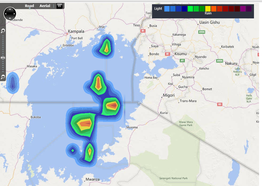
Macintosh HD:Users:greg:Desktop:UNDP:PPP-Publication:Photos:Real-Time Thunderstorm Rainfall Intensity Estimates on Lake Victoria.png
Real-time thunderstorm rainfall intensity estimates as
visualized through the computing infrastructure of the
Pilot Project on Severe Weather Nowcasting Based
on Total Lightning Detection in Lake Victoria Region.
How the System Works
The early warning system installed in Uganda is based on networks of real-time, automatic weather stations installed on existing mobile telecommunication towers and equipped with total lightning sensors. Real-time communications are achieved through a GSM/3G/4G capable modem. This means weather reports will be shared with UNMA every minute, allowing for the creation of early alerts on fast-acting lightning storms.
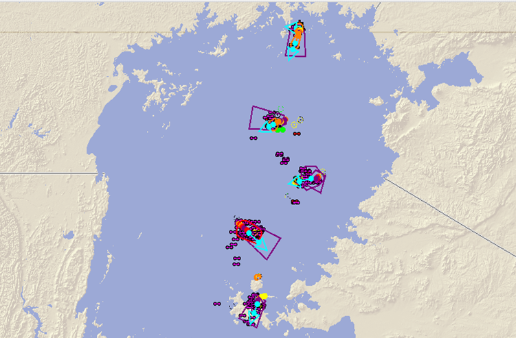
Macintosh HD:Users:greg:Desktop:UNDP:PPP-Publication:Photos:Dangerous Thunderstorm Alert polygons on Lake Victoria.png
The technology generates polygons where
dangerous thunderstorms are active. These polygons can be used by
NHMS to issue early warnings to fisherman and
lake-side communities likely affected by these storms.
In-situ observation data is integrated into cloud-based data repositories as well as nowcasting and numerical weather prediction systems. This solution provides easy access for National Hydro-Meteorological Services (NHMS) such as UNMA to surface observation and forecast data for historical analysis, as well as real-time, current weather conditions and observations.
Displaying data in real time from Uganda’s five new AWS.
The network is already picking up intense
lightning activity in the northwest and
northeast regions of the country. This visualization is available
on the Earth Network tools
such as StreamerRT (PC Based) and the
Mobile application - WeatherBug.
If all the stations are operating with uninterrupted electrical power and internet communications, the pilot network around Lake Victoria provides a cloud-to-ground lightning detection efficiency of over 95 percent for the high resolution area.
It also provides intra-cloud detection efficiency of over 60 to 70 percent in the region, which enables key information on storm development and behavior to be detected in time. When working at maximum capacity, the system provides detailed total lightning data for storm cell identification and tracking in the region and serves as a tool for monitoring of storm intensity, position and movement. Lightning location accuracy is 200-300 meters within the region and less than 400 meters well beyond.
This information is then processed through cloud-computing infrastructure to create an integrated early warning solution. All the data points and layers are visually presented in a specialised display environment, which is utilized by the National Hydro-Meteorological Services (NHMS) to aid in the issuance of early warnings.

Next Steps
The new technology has introduced and aims to sustain total situational awareness across the region with real-time tracking and automated alerts of impending hazards. This means that timely and localized decisions on the issuance of early warnings can be made without having to install expensive, hard-to-maintain weather radar systems across the region.
The need for real-time data products and services requires that UNMA staff be trained to cope with the technological requirements for operation and maintenance, as well as the analysis and interpretation of data.
The new data sets, however, present an opportunity for developing new tailored weather information products for the emerging new markets, which in the long term will help to develop the economic potential and financial sustainability of UNMA.
In the long-term, the public-private partnership with Earth Networks has already delivered $500,000 in co-financing through the donation of assets, hardware and services by the company. When fully implemented this partnership has the potential to deliver an additional $1 million in shared revenue.

Learn More 

With financing from the Global Environment Facility’s Least Developed Country Countries Fund, and supported by UNDP and the Ministry of of Water and Environment, the Strengthening Climate Information and Early Warning Systems (SCIEWS) project in Uganda aims to support adaptation planning via an enhanced climate monitoring network and early warning systems. Securing, transferring and installing critical technologies, as well as developing and integrating the necessary systems for climate change-related information in decision-making processes, the project is working to increase the capacity of the national early warning network to forewarn and rapidly respond to extreme climate events. 

Monday, May 23, 2016

Establishing Emergency Flood Warnings in Benin


Macintosh HD:Users:greg:Desktop:OneDrive:UNDP:Images:General:Impact-Infographic-Benin.jpg

By Arnaud Zannou
In Benin, 800,000 people now have access to early weather warnings, thanks to the establishment of a Standard Operating Procedure (SOP) supported through the UNDP Climate Information and Early Warning Systems Project.

The country issued early warnings for flooding through a multi-agency committee in 2014 and 2015, using manual monitoring of river levels, data processing and information analysis. The country has also adopted a Standard Operating Procedure for the diffusion of alerts through the National Disaster Management Agency.  

Why a SOP is Important
In 2010, Benin faced one of the worst floods in its history. Over 680,000 people were affected and 46 people lost their lives. Areas that were not considered flood prone were devastated with entire villages being wiped out. Damages totaled up to US$260 million.

The crisis was a reality check. The existing crisis communication system was insufficient to reach a large portion of the population. So the Government of Benin began the important task of understanding the communications chain, identifying roles and responsibilities, and defining how early alert messages would be shared.

Making the SOP

The Government of Benin initiated a study to create the SOP. The communications assessment included a review of past efforts, a state of the art, inter-agency brainstorming to create the SOP, SWOT analysis, analysis of the existing communications channels and flows, and finally the proposal of a new communications flow.

In all, the process including meetings with around 20 partner institutions and consultations with 25 districts.

The main goals of the study were to:
  • Identify and analyze the content of all regulations and legislation on the dissemination of alerts related to disasters in Benin. This basic desk study gave an overall picture of how information is shared and responsibilities.
  • Identify and analyze the strengths and weaknesses of existing protocols for early warning dissemination in African countries.
  • Propose a standardized system of communication and warning dissemination. This communication system specifies roles and responsibilities and expected actions from various actors.
  • Identify the legal requirements for the creation of the SOP.
  • Assess specific communications needs of each stakeholder.

Issuing Alert Messages
While the modalities will vary based on institutional mandates, capabilities, legal frameworks, information flows, available information, and end-user needs and behaviors, most experts in disaster management agree that keeping it simple is key.

In the case of Benin, this begins with monitoring by the Meteorological Department, the Hydrological Department and the Oceanographic Institute. Modelling and hydro-climatic risks are driven through the university. The four bodies work in concert to issue warnings passed on through the Disaster Management Agency. 

 ../../Screen%20Shot%202016-05-13%20at%203.11.50%20PM.png

A color-coded system makes it easy for both disaster managers and potentially affected populations to understand the severity and required actions associated with fast-acting storms. Green indicates an all clear, yellow alerts by forecasters indicate vigilance is required by the various agencies, orange alerts are issued to disaster managers to indicate a fast-acting storm or situation that may require immediate action, red alerts means it’s go time. Crisis managers in the SOP are alerted as are all stakeholders. 
../../Screen%20Shot%202016-05-13%20at%203.12.08%20PM.png

Keys to Success
Reliable, accurate and timely information are essential in issuing alerts and fostering a value proposition for climate information and early alerts being produced by National HydroMeteorological Services. Benin has the technical and institutional frameworks in place for climate modelling, and is working to improve hydrological and meteorological monitoring through the UNDP-supported Climate Information and Early Warning Systems Project. This includes the procurement and deployment of 20 Automatic Weather Stations (AWS), 25 automatic hydrometrical stations (deployed in river basins across the country), five automatic oceanographic stations, and one oceanographic buoy.  

The legal framework in Benin ensures each actor knows his or her responsibility and knows and respects the roles of the other actors involved. Because these roles are clearly defined, actors need not refer to superiors when issuing alerts. With multiple agencies involved, messages carry greater weight and credibility, working to create that value proposition lacking for many African NHMS. 
../../Screen%20Shot%202016-05-13%20at%203.13.13%20PM.png

Ongoing Challenges
This doesn’t work overnight. Benin still needs to integrate meteorological monitoring into their early alert system. This type of localized ground truth will improve the fidelity of forecasts and ensure better alerting systems and overall weather and climate monitoring.

The country has the legal framework required to monetize weather and climate data, but has had little success to date in successfully packaging relevant information for use by the private sector.

With no legal framework in place with media to require broadcasters issue early alerts, Benin needs to pay for air time, and is seeking methods to support sustainability for the relationship with media, a key actor in the dissemination of early alerts. Engagement with telecommunications providers is also in the works to disseminate alerts via SMS to cell phones in affected areas, as are alerts through social media.

Resources


Tuesday, April 5, 2016

Creating an Early Warning System

Discover Top Level Takeaways from the Zambia Workshop with our Blog on Applied Learning from the UNDP Last Mile Conference in Zambia


A Simple Step-By-Step Guide


By Bonizella Biagini
Sharing early warnings of fast-moving, rapidly evolving weather phenomena that threaten lives, crops, livestock and infrastructure should be easy… but it’s not. Poor observational data, poor communications, technical limitations, infrastructure limitations, illiteracy, multiple languages, lack of trust, rolling blackouts and myriad other factors make it really, really hard to do – and do well – especially in sub-Saharan Africa. This simple guide taken from the UNDP’s Climate Information and Early Warning Systems Communications Toolkit provides an easy step-by-step process to build an early warning system from the ground up.

According the the WMO, “The primary objective of a warning system is to empower individuals and communities to respond timely and appropriately to the hazards in order to reduce the risk of death, injury, property loss and damage. Warnings need to get the message across and stimulate those at risk to take action.”

In order to do this, one needs to collect and analyze data, package and distribute early warnings, build appropriate processes and response matrixes to allow fast delivery, and share relevant information with stakeholders and actors to ensure people know what do to when bad weather threatens.

Step 1 – Understand the Needs of Your End User
The most important element of creating an early warning system is remembering your audience. Only by knowing and listening to your target market can you effectively share messages with them. We will examine end-user needs and specific messages and advocacy vehicles in a follow-up blog. As you go about designing a solution, it’s important to think about the design process, and re-inject your end-user in every step.   

Step 2  – Collecting and Analyzing Data
“The prerequisite to effective warnings and response is timely, accurate forecasts and ‘nowcasts’ (a forecast for the very near term, generally zero to six hours). These forecasts generally are based on four components: Observational Data and Monitoring Systems; Numerical Weather Prediction; Conceptual Models; and Situational Awareness,” according to the WMO.

Nowcasting messages are generally associated with severe thunderstorm warnings that include heavy rain, large hail, damaging winds and the potential of flash floods. Depending on the communication strategy, the message content can range from a few characters (i.e. twitter or sms) to a more substantial narrative sent via email. Bear in mind that severe thunderstorms in convective environments can develop within 15 to 30 minutes and move at speeds of up to 100 km/hr. It is therefore necessary to convey as much information as possible in a short concise message to a well-defined target audience, those in the immediate path of the storm.

For National Hydro-Meteorological Services (NHMS), the WMO identifies the essential information that should be delivered by the NHMS to support risk identification, reduction and transfer in a functioning early warning system.  
  • Risk identification. Systematic observation and monitoring of hydrometeorological parameters; provision of quality-assured archived and real-time data; hazard analysis and mapping; as well as forecasts of hazards and their changing patterns.
  • Risk reduction. Provision of hazard forecasts and early warnings to support emergency preparedness and response; climate data and forecasts (probabilistic information on hazards and their changing patterns) to support medium and long-term sectoral planning.  
  • Risk transfer. Provision of historical and real-time hazard data and analysis to support catastrophe insurance, bonds and weather-indexed risk transfer mechanisms.

Resources on Collecting and Analyzing Data

Step 3 – Defining Roles
You have good data and good analysis. Now it’s time to share it. In order to avoid disputes over roles and responsibilities, foster buy-in, and build a standard operating protocol for the issuance of early warning messages, you’ll need to assign roles, foster a culture of collaboration and develop non-territorial approaches. Like almost any initiative, the assignment and distribution of roles and responsibilities should begin from the ground up. This will ensure buy-in from all stakeholders. Because every country has its unique political framework, there are no off-the-shelf solutions. However, focusing on a few key areas will help in the definition of roles and responsibilities.

If you look at the roles from the bottom up, you might generalize them in the following way (as adapted from the FEMA roles and responsibilities matrix):

  • Local. Local leaders and emergency managers prepare communities to manage incidents locally.
    • Elected Officials ensure the safety and welfare of the people under their jurisdiction.
    • Emergency Manager. The local emergency manager has the day-to-day authority and responsibility for overseeing emergency management programs and activities.
    • Department and agency heads. Coordinate local services.
    • Individuals and communities. Reduce hazards, prepare for emergencies, monitor emergency communications.
  • States, Territories, Autonomous/Tribal Governments. Support local efforts. They may be charged with regional emergency response, or this responsibility may lay at the local or national level.
    • Governor and elected officials. Communicate with local groups, national groups and affected communities.
    • State Emergency Agency. This may not be applicable in all situations.
  • Federal. In most African nations, emergency alerts will be initiated on the federal level.
    • President. Overall oversight.
    • Ministries. Individual ministries may be responsible for sectorial response and alerts (i.e. hydrology, agriculture, energy, national security, communications)
    • NHMS. Monitor weather and issue alerts (or alert relevant disaster management agency)
    • Disaster Management Unit. Not all countries have a dedicated unit. This revolving point can be used to coordinate warnings.
  • International. On the international level, either the President or Minister of Foreign Affairs would be responsible for international coordination. However, weather alerts should be shared with NHMS in neighboring countries to trigger their own response.
  • Private Sector. The private sector is often responsible for large pieces of infrastructure. In the case of the issuance of early warnings, private telecoms and media companies can also aid in the distribution of warnings.
  • NGOs and First Responders. This group of actors can mobilize supplies, share emergency information and provide response. They can also be mobilized to provide training on what to do in the event of a warning, and as broadcasters for information on required actions in the event of an emergency.

Step 4 – The cycle of Preparedness
The United States has a quick acting early alert system that works across agencies to bring weather alerts to citizens in the blink of an eye. On average, the US does 76 billion observations a year, making 1.5 million forecasts and 50,000 warnings. Here’s how it works.

How does it work? Integrated warning teams, including the National Weather Service (NWS), local media and local emergency managers create and practice year-around a common communication protocol to the public. Trust is obviously key here.

FEMA cycle of preparedness.
Continued public education means most US citizens know “Turn Around Don’t Drown” applies in the event of flooded roads; “When Thunder Roars, Go Indoors”, that is, seek shelter from lightning, and go to hardened shelters or basements for tornadoes.

In a hazardous weather event, the NWS then issues warning polygons by geographic area; these enclose regions likely to be impacted by the weather event in specified times. Once these are issued, the collaborative team creates notifications via text, radio, television through an emergency alert system.

A successful forecast and quick action saves lives. It also means the cycle of trust can continue.


Step 5 – Create a Response Matrix
You are starting to align roles and responsibilities, now it’s time to clearly define the response matrix. Creating a response matrix for early warning issuance will depend on the roles and responsibilities of individual organizations.

Most countries choose to customize their alert levels. A simple yellow, orange, red system is used by the Irish Meteorological Service (Irish Early Warning System). Simple, easy to understand, actionable.
Yellow - Weather Alert - Be Aware

The concept behind YELLOW level weather alerts is to notify those who are at risk because of their location and/or activity, and to allow them to take preventative action. It is implicit that YELLOW level weather alerts are for weather conditions that do not pose an immediate threat to the general population, but only to those exposed to risk by nature of their location and/or activity.
Orange - Weather Warning - Be Prepared

This category of ORANGE level weather warnings is for weather conditions which have the capacity to impact significantly on people in the affected areas. The issue of an Orange level weather warning implies that all recipients in the affected areas should prepare themselves in an appropriate way for the anticipated conditions.
Red - Severe Weather Warning - Take Action

The issue of RED level severe weather warnings should be a comparatively rare event and implies that recipients take action to protect themselves and/or their properties; this could be by moving their families out of the danger zone temporarily; by staying indoors; or by other specific actions aimed at mitigating the effects of the weather conditions. This level of warning assumes a high confidence of the event occurring. Any false warnings could lead to unnecessary panic and loss of credibility.


Step 6 – Package Your Alert
 
You’ve gone through your response matrix. It’s go time. You need to issue an early warning. Packaging that information is just as important as the information itself. 
 

  • Universal symbols. In places with high levels of illiteracy, you should consider the use of universal symbols. The message could be as simple as this: Macintosh HD:Users:greg:Desktop:OneDrive:UNDP:Design:2012_ocha_humanitarian_icon_png_0:disaster_flash_flood_20px_bluebox.pngMacintosh HD:Users:greg:Desktop:OneDrive:UNDP:Design:2012_ocha_humanitarian_icon_png_0:infrastructure_distribution_site_20px_bluebox.pngMacintosh HD:Users:greg:Desktop:OneDrive:UNDP:Design:2012_ocha_humanitarian_icon_png_0:infrastructure_community_building_20px_bluebox.png (flash flood, food will be distributed at the community house) or Macintosh HD:Users:greg:Desktop:OneDrive:UNDP:Design:2012_ocha_humanitarian_icon_png_0:disaster_cyclone_20px_bluebox.pngMacintosh HD:Users:greg:Desktop:OneDrive:UNDP:Design:2012_ocha_humanitarian_icon_png_0:infrastructure_house_20px_bluebox.png (warning cyclone, seek shelter).
  • Sample of an early alert
    message.
    Text should be simple and indicative of the danger, the area, the action and where to get more information or receive support.
  • You will need to package per media. Radio requires audio reports, broadcast requires either text or video reports, SMS requires text.
  • Make sure the response action is clear. You’ve already practiced this in the simulations. Now it’s time to act. This is not a drill. There is a flash flood in your area. Move to higher ground immediately.
  • Questions to ask yourself: Does the alert dissemination plan work with and without electric power? Is the dissemination/communication technology sustainable? Are you building a dissemination strategy that will work long-term, say for a decade or more? Are you disseminating information to people inside buildings or outside? Different communication means may be needed to disseminate the message to these two groups. Especially important in urban areas. What are the restrictions on each dissemination mechanism?

Step 7 – Issue an alert
There’s a fast-acting storm in the Banebe province. You are ready to issue a red weather alert to people living in the storm’s path. Early warnings should be multi-lingual and work across various platforms. They should include information on what to do when bad weather hits. Here’s some tips.


  • Keep the language very simple.
  • Create brand and message local ambassadors. Make sure village leaders, regional leaders have early warnings and can activate local response and further distribution of messages.
  • Maintain constant contact.
  • Create threat levels and types of alerts. For instance, yellow, orange and red (as is the case in Ireland).
  • Integrate hazardous weather alerting with other threat alerting systems (i.e. earthquake, tsunami, and health alerts).
  • Create a community response plan (i.e. training, simulation, awareness building).
  • Conduct regular drills to practice this process, end-to-end.

Once an event is past, go back to step one, re-connecting with end-users to see if the information was effective, how they used it, and how it can be improved.

In its simplest form, this is how warnings are issued.
The WMO Common Alerting Protocol (CAP) “is an international standard format for emergency alerting and public warning. It is designed for all-hazards, related to weather events, earthquakes, tsunami, volcanoes, public health, power outages, and many other emergencies. CAP is also designed for all-media, including communications media ranging from sirens to cell phones, faxes, radio, television, and various digital communication networks based on the Internet.”


Step 8 – Share the Alert
The alert will be shared through your standard operating procedure. Because you’ve assigned roles and responsibilities all the parties and institutions in the information chain know what they need to do. The media is a key player in this information chain. Cell companies, radio and television broadcasters, social media and other media are invaluable actors in this information chain. We include more details on working with media and creating a broadcast early alert system in a follow up blog.

Step 9 – Test, Refine, Replicate, Respond
The US’s cycle of response indicates that all those responsible for some element of the alerting process for severe weather should gain and maintain situational awareness, activate, deploy and coordinate response, then demobilize resources in an emergency. You will need to test and update your system, refine your approach, improve monitoring, replicate best practices, build trust, and respond to needs from relevant stakeholders in the information chain.

Resources


Climate Information and Early Warning Systems Communications Toolkit 
The Communications Toolkit includes easy-to-navigate templates and strategies to issue early weather alerts, create response mechanisms and assign responsibilities in the early-warnings information chain, and create the supportive advocacy strategies necessary to build the enabling political environments necessary to continue with these important endeavors.