Showing posts with label Malawi. Show all posts

Tuesday, March 1, 2016

Scaling Up the Use of Modernized Climate Information and Early Warning Systems in Malawi

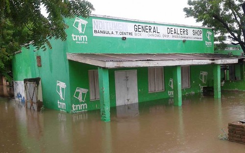
Flooding in Malawi

New UNDP-Supported Project Funded by the GCF Works to Reduce Vulnerability to Climate Change Impacts

By Srilata Kammila
A recently approved project supported by the UNDP and funded through the Green Climate Fund is providing new opportunities to scale up the use of climate information and early warnings in Malawi. The innovative $11 million project focuses on building weather- and climate-related services and has the potential of reaching approximately 2 million people, providing farmers, fishers and communities impacted by a changing climate with the information they need to protect lives and build livelihoods. This includes investing in the use of climate information for planning agricultural and on-farm activities, providing warnings of severe weather for fishers on Lake Malawi, improving flood forecasting and monitoring, and fostering information exchanges through mobile platforms.

Approximately 85 percent of Malawi’s population lives in rural areas with the majority engaged in smallholder rain-fed agriculture. The agriculture sector, including fisheries, remains a key source of economic growth for the country and is extremely vulnerable to climate variability, change and disasters such as floods, droughts, heavy rains and strong winds.

Between 1967 and 2003, the country experienced six major droughts and 18 incidences of flooding, which heavily impacted smallholder farmers. The 2011-12 droughts had severe effects on food security in many districts, with approximately 2 million people affected, particularly in the southern districts. Malawi has just recovered from an intensive flood event in 2015, which left many lives and livelihoods destroyed. It is estimated that the floods affected 1,101,364, displaced 336,000 and killed 104 people.

Currently prevailing drought conditions (due to a strong El Niño) have resulted in extensive crop failures and, combined with rising food prices, up to 2.8m people are facing a worsening food security situation. The current drought comes after a poor 2014/15 season, which also saw poor crop performance, due in large part to a late start of the summer rainfall season (which when it came brought the heavy rains and flooding mentioned earlier).

This combination of consecutive droughts, mixed with heavy floods, makes countries such as Malawi highly vulnerable to climate variability, which is only expected to worsen under a hotter future climate. In particular, increases in temperature will lead to increases in evaporation and water stress, which will negatively affect crop growth, whereas many aspects of the agricultural value chain including drying, storage and transport to market are affected by floods. Increases in the severity of extreme events such as floods and storms (due to rising temperatures and atmospheric moisture) will potentially further exacerbate the hazards faced by both farmers and fishermen. This is of particular concern on Lake Malawi, where fishermen are already forced to search for fish further offshore, regularly encounter severe weather, and take longer to reach the safety of the shore than they did in the past.

Monitoring of the predicted increases in temperature and rainfall variability, as well as the ability to forecast these changes for the coming weeks and seasons, is a key capability that will allow Malawi to effectively adapt to the impacts of climate variability and change. In particular, daily and seasonal weather and climate information can be used by subsistence farmers and fishers to plan planting strategies, crop types, application of agricultural inputs, navigate stormy weather, and plan times and locations for drying fish, etc. Similarly, information on impending floods, taking into account current environmental and social conditions as well as expected and current rainfall across river catchments, enables preparedness activities, which are critical to reducing the vulnerability of communities and livelihoods at risk from flooding.

The Government of Malawi, with the support of UNDP, recently secured funding from the Green Climate Fund to scale up the use of modernized early warning systems and climate information in the country. The project will be implemented by the Department of Disaster Management Affairs (DoDMA), with implementation support from the hydro-met agencies (Department of Climate Change and Meteorological Services and Department of Water Resources), agricultural extension services, fisheries and farmer agencies.

The project will work with communities in 14 food-insecure districts to co-develop tailored weather- and climate-based agricultural advisories to be disseminated through ICT/mobile, print and radio channels. The 3-2-1 service, which allows anyone to access crop advisories through mobile phones, will be enhanced to include weather and climate information (seasonal forecast information and weather conditions). It will also build on existing systems used by the National Association of Small-Scale Farmers (NASFAM) and the Department of Agricultural Extension Services (DAES) who use communication systems (Frontline SMS and ESOKO) for interaction with farmers. The project will develop climate- and weather-related content for distribution to farmers, and strengthen the engagement of the telecom sector to enable expansion of such ICT/mobile platforms.

The project will also scale up the best practices in community readiness to respond to disasters and mitigate key risks. Community-based Early Warning Systems will be scaled up in flood-prone areas and capacities to use and respond to warnings will be strengthened at the national, district and community levels. A key intervention related to this is to strengthen the Emergency Operation Centers, which are critical in planning for disasters, monitoring disasters, and mobilizing resources to manage them. The project will also train communities and civil protection committees to build their capacity for disaster risk management, as well as installing water-level monitoring equipment to help deliver timely warnings.

The project will allow Malawi to extend the coverage of hydrometeorological observational systems, synergizing with ongoing efforts including the LDCF-funded Climate Information and Early Warning Systems Projects.

The expansion of hydromet monitoring stations (including installation of 37 hydrological water level recording stations) and extension of existing forecasting frameworks to the central and northern regions of the country will improve flood risk monitoring, forecasting and water resource planning in the country. Similarly, the installation of 34 Automatic Weather Stations (AWS) will extend the existing coverage to service both the hydrological forecasting and the need for localized weather data to develop the tailored agricultural advisories.

Extension of the severe weather monitoring network will provide information on severe thunderstorms and rainfall for flood forecasting, as well as warnings of lightning strikes and valuable data for developing products that can be combined with existing satellite-based nowcasting systems. This will enable more accurate and timely warnings for fishers over Lake Malawi as well as help forecasters to identify where high-intensity rains may fall. A set of two lake-based weather and wave buoys will be installed on Lake Malawi to measure weather and wave conditions. These will also provide data and information to better predict inclement weather, which poses a danger to fishers; strong Mwera Winds often take lives on Lake Malawi, and the creation of a working early warning system will aid in protecting fishers. 

Resources
•    Strengthening Climate Information in Malawi
•    GCF Approves First Eight Projects

Srilata Kammila
is a Regional Technical Advisor working on Climate Change Adaptation across a number of UNDP-GEF supported programmes in Asia and Africa. Srilata is specialized in developing policies and programs across climate change adaptation and mitigation focusing on climate risk management and advancing climate resilient development.

Wednesday, December 9, 2015

Strengthening Climate Information in Malawi


Lexina Mchakutu: Resident of Salima districts who benefits from
SMS weather updates.
Photo: UNDP Photo by Pauline Achoka

Lexina Mchakutu is from Salima District, Malawi. As the head of her household, she is responsible for feeding her mother, her three children and four of her nephews. Lexina is a farmer; and, like most farmers in the area, she grows maize to feed and support her family.

The effects of climate change have made maize more difficult to cultivate in Malawi, placing serious strains on households like Lexina’s. In recent years, Malawi has been experiencing more frequent and intense floods, droughts, strong winds and other extreme weather—the total annual rainfall in some regions is now exceeding 1,800 mm.

While Lexina receives weather forecasts on the radio and via her phone, the information is often general, without area-specific details. This makes it difficult to predict what to plant and when to plant it. But this is about to change.

Financed by the Least Developed Country Fund and implemented by UNDP, the government of Malawi’s Strengthening Climate Information and Early Warning Systems in Malawi project is taking steps to address these challenges. 

Locations for new weather stations are being identified and forecasting equipment is being purchased. These improvements will give farmers like Lexina access to more accurate and precise climate information and early warnings, thereby increasing their resilience against the effects of climate change. Community members will benefit from 21 new meteorological stations, each of which will include standard rain gauges, thermometers, wind vanes, cup anemometers, evaporation pans, hygrographs, sunshine recorders, telephones and computers. 100 new rainfall observation stations and 53 new Automatic Weather Stations are also in the process of being built.

Although daily radio and TV broadcasts are already used to disseminate warnings, SMS messages provide targeted warnings to areas under immediate threat. Plans are underway to increase the frequency and specificity of SMSs sent to populations in disaster-prone areas.

“Dissemination of weather information though SMS to communities at risk will ensure that people are given timely early warning information to enable them to appropriately respond,” says Mr. James Chiusiwa, Director for Disaster Risk Reduction for the Government of Malawi.

The government is in the process of establishing partnerships with local and regional telecommunication companies so that text messages on weather conditions can be sent to farmers frequently. 280 members of 28 Village Disaster Risk Committees are already receiving the SMS updates and are responsible for disseminating the information to their communities. More community members will be identified to receive these updates, and the circle of people benefitting from the SMSs will continue to widen.

A total of 5,216,285 people from Karonga, Rumphi, Nkhatabay, Salima, Nkhotakota, Dedza, Mangochi, Zomba, Phalombe, Chikwawa and Nsanje Districts will eventually benefit from this project.

This story originally appeared on the UNDP blog on November 19, 2015. 

Tuesday, November 17, 2015

Why we need to save Africa’s historical climate data


UNDP Digitization Initiative Takes Steps To Preserve Historic Climate Data in Sub-Saharan Africa
Archives from the Gambia. Photo: UNDP

By Excellent Hachileka
Climate data is the lifeblood of early warning systems and the cornerstone for resilience building efforts. It not only allows us to monitor adverse impacts across development sectors, populations and ecosystems, but it also helps countries to prepare for and adapt to the realities of climate change. This priceless information can be analyzed and applied to protect development gains and aid in the achievement of National Adaptation Plan goals.

Unfortunately in many parts of sub-Saharan Africa, this important data – often recorded with pen and paper – is being lost at a remarkable rate. Civil War, decay and the sands of time are literally erasing our historical record of climate in the region. In order to preserve this essential data, it is critical that Africa take steps to digitize this information.

At the request of the governments of the Gambia, Malawi, Sierra Leone, Tanzania, Uganda and Zambia, the UNDP Programme on Climate Information for Resilient Development in Africa (CIRDA) is taking steps to preserve this data. Two experts – including myself – where commissioned by CIRDA to meet with National Hydrological and Meteorological Services to provide guidance on digitization efforts and create a plan to capture digital records, especially information relevant to agriculture, fishing and flood management.

The lessons learned from our initial efforts to provide guidance on digitization can be applied to other countries, and is an important first step in securing the historic record of Africa’s climatic past.

Climate data generally falls into two categories: historical data and data from recent and current observations.

While most people understand the importance of current and recent climate data, fewer appreciate the equal importance of historical climate data. Historical data allow us to establish long-term trends, which in turn helps us understand and better plan for future changes in climate. They also help us develop climate models and seasonal forecasts, and provide the foundational datasets used for adaptation studies at local, national and regional scales.


For example, climate models are mathematical representations of the interactions between the atmosphere, oceans, land surface, ice and the sun. Once a climate model is developed, it has to be tested to find out if it works. And since we can’t wait for 30 years to see if a model is any good or not, the models have to be tested against the past in a process that is called “hindcasting.” These models rely on historical observations. The simple assumption of hindcasting is that if a model can correctly predict current trends from a starting point somewhere in the past, one can expect it to predict with reasonable certainty what might happen in the future.

Meteorological data observations in most African countries date back to the early 19th Century (for example, in Tanzania the first meteorological observation was made along the coast in 1850). Once recorded on paper, the observations are kept in various formats in data archives located in meteorological agencies. But this historical data is recorded largely on paper and, depending on the age of the paper and the condition of the archives, some of the data is unreadable or is wearing out at dramatic rates, while other data is recorded with handwritten ink that fades over time. This is a slow-motion tragedy. Historical information is an invaluable resource for a continent that is already being hit hard by climate change.
 

Some of these countries have almost one billion pages of historical data that is not digitized. That’s a lot of paper and a lot of work, but it also represents decades of historical information that can prove critical in long-term forecasts. These billion pages represent the records from just the six countries we visited, and the situation is similar throughout much of Africa. 

Many of the National Hydrological and Meteorological Services we visited expressed a great deal of concern in the ongoing loss of this information. For instance, a chief meteorologist at the Zambia Meteorological Department told me that one day he woke up to learn that a colleague in his office had set a large portion of climate data on fire in a bid to create more office space – literally, several years of irreplaceable data had just vanished into smoke. In other places, the poor conditions of archives have led to climate data being eaten up by termites or destroyed when offices are flooded. In Sierra Leone, the Meteorology Department points to thousands of historical climate datasets that were lost during the civil war.
 

As should be clear, preserving historical data isn’t just an exercise in saving bits of old paper – it is an investment that can truly save lives and enhance climate risk preparedness by helping to create better forecasting, better projections and better early warning systems. Indeed, ensuring that all historical climate data is rescued and digitized can contribute to improving efficiency and effectiveness in the provision of climate services. Perhaps more importantly, it is an essential building block to fortify our societies’ resilience against the effects of climate change.

Hot Links
Excellent Hachileka is an Environmentalist and Development Expert with over 20 years of environmental management and development work in sub-Sahara Africa. He is currently serving as a Programme Specialist in the Disaster Risk Reduction and Climate Change Cluster at the UNDP Regional Service Centre for Africa (RSCA) where he provides technical support to UNDP Country Offices and the Regional Economic Communities in Africa. His work focuses on the development of integrated disaster risk reduction and climate change policies, legislation, regulatory frameworks and strategies. Before joining the RSCA, he worked as a Climate Change Policy Specialist at UNDP Zambia. He has also worked for 12 years with the International Union for Conservation of Nature (IUCN) as Country Director for Zambia and Zimbabwe, and as IUCN’s Regional Climate Change Programme Coordinator for Eastern and Southern Africa. Excellent was also a Lecturer and Researcher in Environmental Management and Natural Resource Economics at the University of Zambia. He holds a BSc in Physical Geography (University of Zambia) and a Master’s Degree in Environmental Management (University of Stirling, Scotland).