Showing posts with label telecommunications. Show all posts

Tuesday, June 7, 2016

Uganda Pioneers Lightning-Based Early Warning System

New Automatic Weather Stations Installed on Cell-Phone Towers Improve Storm Forecasts and Protect Lives
By Pascal Onegiu Okello
KAMPALA - Uganda’s weather reporting is destined to become one of the best in the East African region after the installation of a network of five all-in-one Total Solutions Automatic Weather Stations (TSAWS).
The five stations, which include a total lightning detection system, will provide improved weather reports, issue early warnings for fast-acting lightning storms, connect Uganda with regional monitoring systems and improve the country’s overall sustainability of investments in climate information services.
The TSAWSs, which were procured by the Uganda National Meteorological Authority (UNMA) through the UNDP-supported Strengthening Climate Information and Early Warning Systems Project, will work in concert with six already existing lightning sensors from the “Pilot Project on Severe Weather Now-casting Based on Lightning Detection in Lake Victoria Region.” This brings the total number of TSAWS sensors in Uganda to eleven.
The increased number of total lightning detection stations will now provide coverage for the Central, Eastern and Northern region of the country, and hopefully reduce the number of lightning fatalities in the country, which has been noted to have more lightning fatalities per year than anywhere else in the world.
Lightning strikes killed over 205 primary school children between 2012 and 2013. Apart from lightning, fast-acting storms and unpredicted high winds are also a cause of worry as some estimates show that around 5,000 people perish each year on Lake Victoria due to them.
The Total Solutions AWS will also integrate lightning data from neighboring networks in Burundi, Kenya and Tanzania, making for improved regional cooperation in early warning systems.
All this is part of the Government of Uganda’s efforts towards building early warning systems, with the support of UNDP’s Programme on Climate Information for Resilient Development in Africa (CIRDA) and funding from the Global Environment Facility (GEF)’s Least Developed Countries Fund.
A Focus on Sustainability
In an effort to ensure that the stations are able to work well, UNMA has partnered with local telecommunications companies, which allowed them to install the TSAWSs on their towers in the five districts of Kaliro, Sironko, Napak, Kotido and Agago (Otuke).
This not only reduced installation costs but also ensures that the stations have a continuous supply of power and communication for monitoring them as well as security from vandalism.
In addition, Earth Networks, a private weather services provider that was procured to provide the equipment, also integrated this new-generation of weather-monitoring equipment into UNMA’s existing monitoring system.
They also trained seven UNMA technicians on how to install the stations so that they are not only able carry on this installation process but also monitor it for efficient use.
“During the first installation in Kaliro, as we completed the assembly of the sensor on the ground and prepared for the hoisting, we observed some rain clouds in the distance. Since we heard no thunder, we assumed it to be safe to send the rigger up to begin the installation. However, the Earth Networks project manager logged into the WeatherBug App and saw lightning activity within 3km of the site. He advised that we wait a few minutes before proceeding,” Georgie George, Alternative Technologies Specialist for the CIRDA Programme, said.
He added that using the App enabled them to make an informed decision that kept them safe from the heavy downpour and lightning.
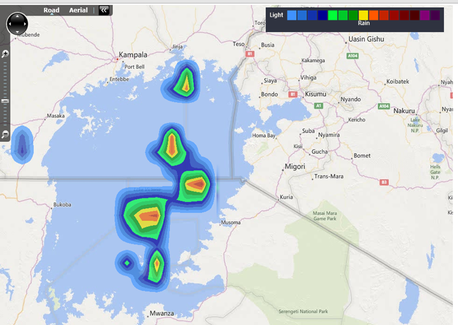
Macintosh HD:Users:greg:Desktop:UNDP:PPP-Publication:Photos:Real-Time Thunderstorm Rainfall Intensity Estimates on Lake Victoria.png
Real-time thunderstorm rainfall intensity estimates as
visualized through the computing infrastructure of the
Pilot Project on Severe Weather Nowcasting Based
on Total Lightning Detection in Lake Victoria Region.
How the System Works
The early warning system installed in Uganda is based on networks of real-time, automatic weather stations installed on existing mobile telecommunication towers and equipped with total lightning sensors. Real-time communications are achieved through a GSM/3G/4G capable modem. This means weather reports will be shared with UNMA every minute, allowing for the creation of early alerts on fast-acting lightning storms.
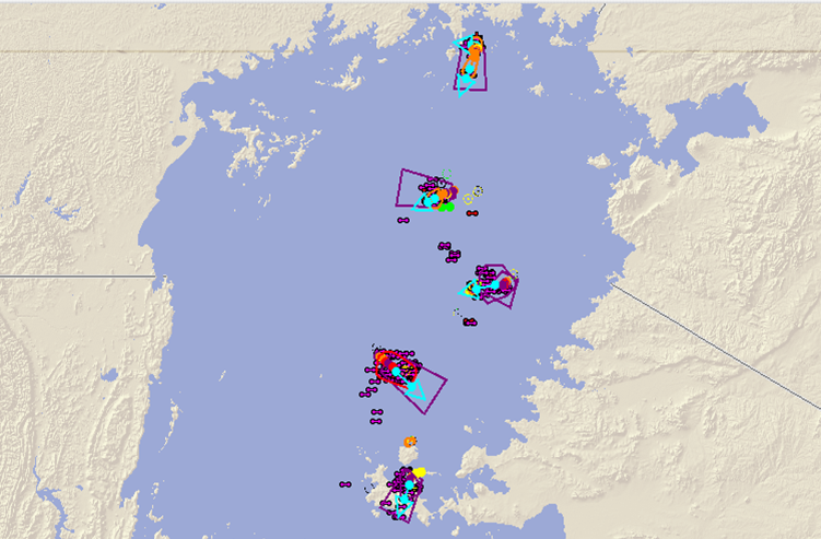
Macintosh HD:Users:greg:Desktop:UNDP:PPP-Publication:Photos:Dangerous Thunderstorm Alert polygons on Lake Victoria.png
The technology generates polygons where
dangerous thunderstorms are active. These polygons can be used by
NHMS to issue early warnings to fisherman and
lake-side communities likely affected by these storms.
In-situ observation data is integrated into cloud-based data repositories as well as nowcasting and numerical weather prediction systems. This solution provides easy access for National Hydro-Meteorological Services (NHMS) such as UNMA to surface observation and forecast data for historical analysis, as well as real-time, current weather conditions and observations.
Displaying data in real time from Uganda’s five new AWS.
The network is already picking up intense
lightning activity in the northwest and
northeast regions of the country. This visualization is available
on the Earth Network tools
such as StreamerRT (PC Based) and the
Mobile application - WeatherBug.
If all the stations are operating with uninterrupted electrical power and internet communications, the pilot network around Lake Victoria provides a cloud-to-ground lightning detection efficiency of over 95 percent for the high resolution area.
It also provides intra-cloud detection efficiency of over 60 to 70 percent in the region, which enables key information on storm development and behavior to be detected in time. When working at maximum capacity, the system provides detailed total lightning data for storm cell identification and tracking in the region and serves as a tool for monitoring of storm intensity, position and movement. Lightning location accuracy is 200-300 meters within the region and less than 400 meters well beyond.
This information is then processed through cloud-computing infrastructure to create an integrated early warning solution. All the data points and layers are visually presented in a specialised display environment, which is utilized by the National Hydro-Meteorological Services (NHMS) to aid in the issuance of early warnings.

Next Steps
The new technology has introduced and aims to sustain total situational awareness across the region with real-time tracking and automated alerts of impending hazards. This means that timely and localized decisions on the issuance of early warnings can be made without having to install expensive, hard-to-maintain weather radar systems across the region.
The need for real-time data products and services requires that UNMA staff be trained to cope with the technological requirements for operation and maintenance, as well as the analysis and interpretation of data.
The new data sets, however, present an opportunity for developing new tailored weather information products for the emerging new markets, which in the long term will help to develop the economic potential and financial sustainability of UNMA.
In the long-term, the public-private partnership with Earth Networks has already delivered $500,000 in co-financing through the donation of assets, hardware and services by the company. When fully implemented this partnership has the potential to deliver an additional $1 million in shared revenue.

Learn More 

With financing from the Global Environment Facility’s Least Developed Country Countries Fund, and supported by UNDP and the Ministry of of Water and Environment, the Strengthening Climate Information and Early Warning Systems (SCIEWS) project in Uganda aims to support adaptation planning via an enhanced climate monitoring network and early warning systems. Securing, transferring and installing critical technologies, as well as developing and integrating the necessary systems for climate change-related information in decision-making processes, the project is working to increase the capacity of the national early warning network to forewarn and rapidly respond to extreme climate events. 

Monday, April 4, 2016

Applied Learning from the UNDP Last Mile Conference in Zambia


Connecting Last Mile Weather and Climate Products to National Hydro-Meteorological Services

The UNDP’s Programme on Climate Information for Resilient Development in Africa (CIRDA) Last Mile Conference in Zambia brought together leading thinkers in both the public and private sectors to discuss how weather and climate information can be applied to save lives and improve livelihoods.

There were discussions on communications, market forces and sector-wide imperatives, application development, enabling policies and more. We’ll be sharing the top lessons learned in a series of ongoing blogs. But it’s important to take a 50,000-foot view of some of the top outcomes of the meeting.

Country Updates
As most Climate Information and Early Warning Systems Projects enter mid-term review, now is a good time to start messaging impact and share important lessons learned. Getting it started, UNDP experts defined the goals of the workshop and the very space that encompasses “The Last Mile,” and country programs presented key takeaways half-way through project implementation. 


Country Presentations
Climate Action Hackathon
Stories from the Hackathon continue to roll in on the Climate Action Blog as the five teams (and one team forming virtually) continue to scale up, test and improve the applications they developed in Zambia.

“The Hackathon was an incredibly enabling environment for developing tools for climate and weather,” says Knife’s Edge team member Madi-JImba Yahya. “The panel sessions provided good insight into the underlying problems that plague climate issues, and helped Hackathon participants better understand the gaps that exist in the climate and weather industry, and its indirect impact on the public good.”


The Knife’s Edge team worked to develop a promising app that connects agricultural extension workers with a weather information dashboard that they can use to inform local farmers.

“While most of our team had heard about climate change and its impacts on the various sectors of the economy, what surprised us is the crucial role climate and weather information plays, as well as the expansiveness of sectors impacted,” says Teddy Odindo of the Climar Team, who developed a voice-messaging app to share relevant agro-climatic information in local languages.

The Hackathon was a breeding ground for innovation. The five onsite teams worked together to use design thinking principles to drive innovative applications for the sharing of weather and climate data.

“We were also surprised by the level of diversity in terms of skills and experience in our team, ranging from a coding expert, educator, GIS expert and business expert, to a climatologist as well as practitioner in climate change adaptation,” said Odindo. “Lastly, we were amazed by the huge number of companies and people working to bring climate services closer to the people who most need it. There exists a number of opportunities for us to work with other organizations to improve access to climate information.”

As the Hackathon moves into its virtual phase, partners from The Brown Institute for Media Innovations – a bi-coastal collaboration between Stanford’s School of Engineering and Columbia’s Graduate School of Journalism – and The International Research Institute for Climate and Society (IRI) will work with UNDP experts and country partners within National Hydro-Meteorological Services (NHMS) to scale up the innovations and create final products.

3-2-1 Action
With progress reports coming in from the CIRDA-supported Climate Information and Early Warning Systems Projects, one thing in particular stood out. Most countries supported through the CIRDA programme are now very actively engaged with Human Network International’s 3-2-1 service.

“CIRDA is serving as a knowledge broker and partnership builder, connecting innovative enterprises like Human Network International’s 3-2-1 service with National Hydro-Meteorological Services. By fostering these types of partnerships, we are working to take weather and climate data across the last mile,” says CIRDA Programme Manager Bonizella Biagini.

A number of other value-add services presented at the Zambia workshop, providing a new menu of services, service providers and unique approaches that African NHMS and Disaster Management Units can choose from to build tailored weather services and package weather information.


Communications
An entire learning arch was dedicated to communications. During that arch, the CIRDA Programme shared a Communications Toolkit that includes easy-to-navigate templates and strategies to issue early weather alerts, create response mechanisms and assign responsibilities in the early-warnings information chain, and create the supportive advocacy strategies necessary to build the enabling political environments necessary to continue with these important endeavors.

The use of agricultural extension services wasn’t just highlighted by the Hackathon teams, the Zambia Climate Information and Early Warning Systems Project is also looking to leverage extension services in a unique way, by placing information kiosks within agricultural extension offices. As with the design thinking process applied in the Hackathon, good communications starts with an intimate understanding of end-users. On the second day, country programs broke into teams to develop applications and messages based on the communications learning arch, with Burkina Faso and other countries presenting draft strategies to the plenary hall.  


Understanding Market Forces
Two upcoming publications and studies took center stage on the second day of plenary sessions. These included a much-anticipated publication entitled “A New Vision For Weather and Climate Services in Africa” and an in-depth UNDP market study conducted by C4Ecosolutions that is being shared as a draft to gain input and insight from the community of practice as well as NHMS across Africa.

“A New Vision for Weather and Climate Services in Africa” examines the climate information and services space in sub-Saharan Africa, taking a critical look at what hasn’t worked, why it’s important and possible solutions. The report is slated to launch soon. Can’t wait? Here’s a preview.  

The Market Study was conducted across the continent and dives much deeper into end-user needs, demand and market forces both on the supply and demand side of the weather services value chain.
   
This excerpt provides a tantalizing glimpse at the information contained in the report, which was designed as a unique third-party perspective to truly understand the way climate services are developing in sub-Saharan Africa.  

“Where markets for climate and weather information products have developed particularly successfully – e.g. in the USA and the Netherlands – NHMSs have been central to the process. A fundamental role of the NHMSs in these cases has been to provide good quality data and derived products from their extensive observation networks. This has enabled private weather companies to improve both the quality and the quantity of their products and services, and to develop new markets by providing tailored products and services catering to the needs of specific niches. Such government-provided data invariably underpin the growth of the commercial weather market, enabling companies to thrive. Another effect of a flourishing commercial weather market is to increase the status of the NHMS within both the private and public sectors, which in turn facilitates investments by government and the private sector into building the human resource capacity as well as infrastructure of the NHMS.

“This market assessment investigated how flourishing commercial weather markets could be catalysed in the countries supported by the CIRDA programme, and how NHMSs could maximise their benefit from such markets. Two main conclusions emerged from the assessment. Firstly, NHMSs should collaborate rather than compete with private sector weather companies; and secondly NHMSs should embark on phased, slow transitions into entities that derive benefits from the national commercial weather markets.”


How will all these lessons be applied by UNDP-supported, GEF-financed Climate Information and Early Warning Systems Projects, NHMS, Disaster Management Units, and other relevant stakeholders? It will take continued dialogue, enabling policies, constant contact with end users, and just a bit of hard work.

Monday, February 15, 2016

Econet in Zimbabwe

Photo from the EcoNet Farmer website.


In Zimbabwe, the market-leading telecommunications provider EcoNet Wireless, is packaging and distributing valuable information such as farming tips, health advice, weather information and mobile banking options to engage with rural customers, build brand loyalty, and support the overall image of the company. The company has launched a wealth of feature-phone enabled subset brands, such as EcoCash, EcoHealth, EcoSchool and EcoFarmer.

“EcoFarmer is a revolutionary way of farming using mobile technology. It is Zimbabwe’s first micro-insurance product designed to insure inputs and crops against drought or excessive rainfall. In addition the insured farmer will also receive daily weather information, farming tips and information on when and where to sell, and the best price for their produce,” according the platform’s website. 

The EcoFarmer platform includes the following pieces of information:
·      Daily weather data from a weather station linked to your field.
·      Farming and market tips
·      Free daily rainfall advice
·      Free weekly best farming prices
·      Free weekly crop data
·      Free monthly market pricing requests
·      Crop information
·      Credit rating
·      Free adverts and marketing links
·      Financial linkages
There are three basic levels of subscription. General Farmers get very basic information for free, Registered Farmers provide some information (a monetizable asset for telecommunications firms) and receive expanded information, while Insured Farmers receive all the information, plus a supporting insurance policy. By subscribing to the services for 8 cents per day for 125 days, Insured Farmers are said to be guaranteed a harvest or at least $100 for every 10kg of seeds planted. In an obvious partnership with a sponsor, the seeds have to be SeedCo brand. They provide this micro-insurance “regardless of the weather conditions,” meaning this is not true index-based insurance, rather a smart marketing scheme designed to engage customers, but it’s working and the modality is an interesting one for other African nations. There are currently an estimated 300,000 subscribers. They spun-off the EcoFarmer service in 2015, to launch a separate new service called “Dial-A-Mudhumeni,” a partnership with Zimbabwe’s Ministry of Agriculture that connects smallholder farmers with agricultural extension workers.

Where does the weather information come from? Econet has developed a network of cell-tower-based stations to monitor weather patterns including rainfall, temperature and humidity.  According to TelecomPaper, “Zimbabwe operator EcoNet has inked a partnership agreement with the Metrological Services Department to provide weather information to smallholder farmers. The MSD issues weather forecasts to the public, and EcoNet provides the data platform for distribution. The MSD's new weather station automatically records the parameters and transmits the data to MSD remote stations and its offices in Harare via SMS. The data received at the MSD in Harare will be relayed to the Ministry of Agriculture, Mechanisation and Irrigation Development for policymaking. The new system for weather measurement and monitoring will be installed throughout the country to assist smallholder farmers in accessing information.” They locate the farmers using a smart application connected with the seeds. The seed packs hold a small, plastic container with a specific number that the farmer must send to the network via SMS. As soon as the number is received, the farmer’s location will be noted, and rainfall in the area will be monitored. 

Hot Links
·       Esoko 

Video